- Data
- Hosted data systems
- Sea level
- International
International sea level
The international sea level data available are a combination of data collected under the the Global Sea Level Observing System (GLOSS), the World Ocean Circulation Experiment (WOCE) and the Climate Variability and Predictability (CLIVAR) programmes.
This high frequency delayed-mode data set provides quality controlled data from stations in
- The GLOSS Core Network
- The network identified by the CLIVAR programme for ongoing climate monitoring
- The network identified by the Global Climate Observing System (GCOS)
The data assembly began with WOCE in early 1991 and continued until 2002. CLIVAR, evolving from WOCE, started in 1995 and will have a lifetime of 15 years. Towards the end of the WOCE period BODC, jointly with the Permanent Service for Mean Sea Level (PSMSL), became a GLOSS data archiving centre.
Data availability
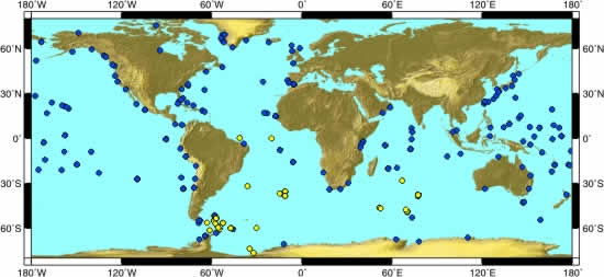
The map below illustrates the sea level data coverage. Blue dots are coastal tide gauge sites and yellow dots are bottom pressure recorder deployments. For ease, data and accompanying documentation have been divided into the following

Both WOCE and CLIVAR recognised the need for the establishment of two Sea Level Data Assembly Centres (SLDACs). The two centres perform complementary activities. BODC is responsible for constructing the data set suitable for archiving and long term preservation, and the University of Hawai`i Sea Level Center (UHSLC) for producing data sets that are corrected and ready for use by scientist and educators.
Data format
Data are available in either BODC request (ASCII) or WOCE netCDF format and are supplied as 'zip' compressed files.
Data retain their original sampling intervals and all parameters including any ancillary measurements (e.g. temperature, wind speed/direction, atmospheric pressure) are presented.
Data have undergone BODC quality control procedures and have been flagged to indicate null, suspect, or interpolated values, and also datum changes as appropriate. No data values will have been changed without the permission of the data collector.
For ease, a sample MATLAB and Fortran routine is provided for your use to read these sea level data.


